.png?width=400&height=150&name=Copy%20of%20G2%20Image%20(1).png)

Before opening a new outlet for your brand, you have to pay attention to the tangible outcomes and dangers you might face.Any new construction project requires a prior evaluation of the local population, geospatial analysis, and sales potential for a specific area.
As someone who is always curious about project planning and analysis, I wanted to learn about the process of analyzing land-centric operations and community planning for brands.
That's when I came across GIS software (Geographic Information System), a pivotal tool that analyzes aerial imagery, builds location maps, and predicts potential risks of a particular piece of land.
Curious to know more, I evaluated and analyzed the 6 best GIS software that can build location prototypes, list census data, and detect new land-based routes to optimize business operations.
Whether you are an early adopter or a seasoned entrepreneur, this list of the best GIS software can help you analyze the social, economic, and geographical parameters of a particular area to plan future strategies.
The major role of GIS software is to derive a correlation between location data and real-world consumer data to plan a future course of action for companies so that they can make human-centric decisions, decrease crime activities, spread disease awareness, and build earth-conscious communities.
When I began my journey with GIS software, I discovered its numerous benefits for various land-centric industries. With this software, one could capture photographic and cartographic data, analyze aerial imagery, and build 3D prototypes to understand how these tools support future construction projects or evacuation management strategies.
I analyzed how the tool handled various topographies, including land, water, soil, air, roads, alleys, hills, areas, and boundaries, to set different navigational parameters and conduct in-depth data-driven manipulations.
What really underscored the importance of GIS was its market growth: the global geographic information system market is projected to grow to around USD 24.61 billion by 2034, at a CAGR of 8.71%.
I spent weeks trying and testing multiple GIS software based on their features, pros and cons, pricing, business size availability, and real-time user reviews. I looked for the latest features like geospatial mapping, geocoding, the Internet of Things, buffer querying, AI-based object tracking, power sensors, and satellite communication to bring forth the best of the bunch for your informed decision-making.
In cases where I couldn’t personally test a tool due to limited access, I consulted a professional with hands-on experience and validated their insights using verified G2 reviews. The screenshots featured in this article may be a mix of those captured during testing and ones obtained from the vendor’s G2 page.
Within this process, I also made use of AI to narrow down customer sentiments, the latest trends and highlights, investment-related details, and optimization levers in land-centric operations as listed by G2 users. These software providers have also been filtered based on a proprietary G2 score, which is an aggregate of buying parameters such as ease of administration, ease of budgeting, ease of implementation, market presence, and customer satisfaction, presenting an all-around picture at your disposal.
While exploring different GIS software, I found that these tools can deliver highly varied results depending on the industry and use case. Many of them are used to build smarter communities, support socio-economic and cultural planning, and even help reduce crime rates.
Since I’ve been researching, I focused my evaluation on key capabilities that stood out across multiple GIS platforms and user insights:
Overall, my exploration reinforced that GIS software is most valuable when it combines strong analytical capabilities with flexibility, scalability, and real-world integration.
To be included in this category, software must:
*This data was pulled from G2 in 2025. Some reviews may have been edited for clarity.
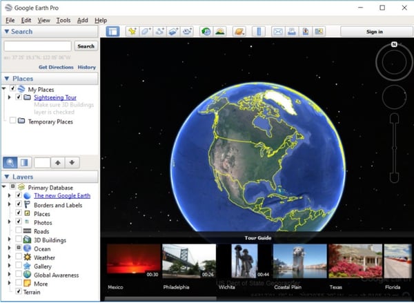
Google Earth Pro offers precise and high-resolution imagery, 3D modeling, site tracking, and 3D navigation services to explore various locations around the globe and implement big data processing to launch mega projects.
I have utilized Google Earth Pro for a wide range of applications, from casual virtual travel to more in-depth mapping projects, and have created accurate routes and maps to achieve positive business outcomes.
What I liked most was the availability of satellite imagery and digital data processing services to users. I can view high-resolution images of cities, mountains, oceans, and just about any place on Earth. Furthermore, the 3D terrain view adds a whole new level of immersion, enabling me to analyze and interpret geospatial data and identify new terrain features. As per G2 Data, 88% users praise its data capture capabilities.
One of the most appreciative features it offers is the street view. It is the same as dropping a pin on the map. You simply need to identify a location and click the cursor to register it. Then, you get a real-time view, as if you are walking down the street.
What sets Google Earth Pro apart from the standard version is the advanced mapping and GIS tools. I can measure distances with precision, overlay different datasets to establish interdependencies, and even import GPS data for clear navigation. These features were incredibly helpful for projects that required detailed geographic insights, such as creating a school transportation system or constructing a community center.
Google Earth Pro offers accurate geospatial analysis, providing detailed insights into various locations and demographics. That said, there are some ebbs and flows in its performance. Occasionally, the imagery can be outdated or blurry, particularly in less populated areas, something a few G2 users have also noted. Despite this, the platform’s analytical capabilities remain strong.
I have also noticed that when loading large datasets or toggling between multiple layers, the software can slow down or crash. While the main interface gets the job done, it occasionally feels a bit outdated. That said, its integration with 3D modeling and mapping software still allows for generating designs and rasters effectively, which is a major advantage for expanding business applications.
Overall, Google Earth Pro combines powerful mapping and modeling features with reliability in geospatial tasks. Even with minor performance hiccups, it remains a valuable tool for businesses seeking detailed location-based insights.
"Google Earth Pro's high-resolution imagery empowers precise site analysis, while GIS data integration enhances impact assessments. The 3D measurement feature ensures accurate quantification of potential effects. It's a video creation, and high-quality visuals streamline presentations. In the realm of Environmental Impact Assessment reports, Google Earth Pro seamlessly blends advanced tools with a user-friendly design, optimizing both efficiency and outcomes."
- Google Earth Pro Review, Monika N.
"Sometimes the program is a little sensitive when using an optic mouse and will zoom in or out a bit when you don't mean to -- but this is really a very minor thing (and probably more the fault of the mouse sensitivity, or the user, lol)"
- Google Earth Pro Review, Amie S.
Learn the ins and outs of GPS tracking and its pivotal role in building high-resolution maps to implement your industry-specific predictions for any demographic.
Esri ArcGIS sets a standard for GIS tracking. It offers a suite of data management and predictive modeling services to build structured maps, analyze trends, and monitor the real-time community expansion of a particular area.
Esri ArcGIS has been my go-to tool for mapping, spatial analysis, and geoprocessing. It offers endless possibilities for creating a future-proof business strategy.
Whether I am working on a GIS project, city planning, or simply exploring geospatial data, ArcGIS has provided me with a set of robust tools for planning, analysis, and implementation.
The highlight here is the platform's flexibility and agility. I can work both online and offline, which is super useful when I am in remote locations or dealing with unstable internet connectivity. I was able to build 3D drafts for network design, urban planning, and environmental monitoring. The platform's spatial analysis capabilities also allowed me to overlay multiple datasets and analyze geographical patterns.
ArcGIS also allows for extensive API access, enabling me to tailor it to my specific needs, whether involving Python scripting, ModelBuilder, or advanced automation workflows. As I am involved in remote sensing, geoprocessing tools have also helped me manipulate raster and vector data with ease. The integration of Google Maps has further simplified map analysis workflows.
I felt that pricing was a little on the high side. On the other hand, I had the option to choose from various subscription tiers that catered to my specific needs, which made it easier to find a plan that fit my usage.
Running ArcGIS also requires high-performance hardware. If my computer weren't up to speed, I might have experienced some lag. G2 users reported similar experiences, particularly when working with high-resolution maps or large datasets. Despite this, the software runs smoothly on capable systems and efficiently handles complex GIS tasks.
I also noticed that the training curve can be quite steep. Once I learned the platform, it became incredibly powerful, but mastering it required patience and time. With persistence, however, the learning investment pays off with robust functionality for advanced projects.
Overall, Esri ArcGIS is user-friendly and versatile, making it well-suited for GIS instructors, urban planners, and real estate agents who work with land-centric projects on a daily basis. Its strengths in analysis and mapping make it a valuable tool for professional GIS workflows.
"I have used ArcGIS for many years for spatial analysis. The best part is the visualization of all rasters and vector data in one frame, which can include Google Maps in the background. Digitizing is very easy. This software can be used to create maps as required and needs to be added to any project report."
- Esri ArcGIS Review, Heena K.
"Creating the perfect environment can take some time. You'll need to understand all relevant aspects of your business to know exactly what can be shown on a map in real-time."
- Ersi ArcGIS, Chase C.
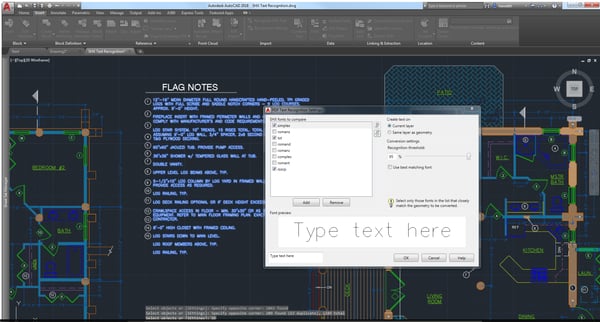
3. AutoCAD: Best for data modeling and terrain editing
AutoCAD provides real-time sketching, drafting, and circuiting capabilities, enabling data science and engineering teams to create innovative visualizations of their upcoming manufacturing projects and align with all stakeholders on designs. In fact, as per G2 Data, 84% users praise its visualization capabilities.
AutoCAD is one of those tools that, once mastered, is a go-to tool for drafting, designing, snipping, and creating 2D or 3D prototypes. I loved the command-line feature, which enhances workflow efficiency and allows me to execute tasks without taking shortcuts.
With a comprehensive library of tools, including dimensioning, hatch patterns, and layer management, AutoCAD ensures that the designs remain precise and clean, and also offers real-time editing based on other influential factors or changes.
However, learning AutoCAD required some time. As I was new to the user interface, it initially felt a bit overwhelming. It took me a while to understand the various customization options, macros, scripts, and tool palettes, but once I did, I was able to start creating my own designs efficiently.
Another aspect I noticed is pricing. AutoCAD isn’t the most budget-friendly option, and the subscription can feel a little expensive. Working with larger datasets and files may occasionally cause slowdowns, and G2 users have mentioned that while AutoCAD’s 3D capabilities are intuitive and crisp, they don’t fully match the quality of Revit or Fusion 360. Still, these issues are minor compared to the tool’s overall versatility.
Regardless, AutoCAD remains a high-end and competitive design tool, widely preferred by construction engineers and automotive teams around the world. Its advanced features and reliability make it a top choice for professional design workflows.
"AutoCAD is super productive for 2D drawings (drafting and annotation). It allows me to create multiple or very large technical drawings (blueprints) and building plans with less fear of error due to broken relationships, which is to common issue with parametric design software. AutoCAD has unique abilities like the use of layers, blocks, reference, and Osnaps, which make your drafting experience unforgettable."
- AutoCAD Review, Ofonlime W.
"Lack of Cloud-Based Collaboration: Unlike some newer design tools, AutoCAD's collaboration features are not as robust, which can be a limitation for teams working remotely."
- AutoCAD Review, Khalid A.
ArcGIS Online provides comprehensive geospatial analysis and mapping capabilities, enabling you and your team to develop a data-driven and comprehensive task management strategy and gain a holistic understanding of real-world locations and places.
ArcGIS Online is all about mapping, spatial analysis, and data visualization, but what made it more powerful was its integration within existing project workflows.
Since it is cloud-based, I can work on my maps and data from anywhere without having to deal with annoying installations or hardware limitations. The user interface felt pretty intuitive, and it connected with ESRI applications to substantiate maps with data-driven variables and create foolproof plans.
Whether I am creating layers, adding datasets, or publishing maps for my team, the platform makes the processes very convenient. I can even collaborate with my colleagues, stakeholders, and even the public and control who gets to see what with role-based access control.
The selection of spatial analysis tools is impressive because I can run everything from basic overlays to advanced location intelligence operations with a single tool. The 3D visualization tools were also useful during urban planning and terrain analysis. If you are into web GIS like I am, you can also build interactive dashboards and web maps to gain insightful data for your next project.
That said, no software is perfect and has areas for improvement. I did spend some time learning and configuring the platform. ESRI provided documentation and training resources, but I definitely had to spend some manpower learning all the advanced features and functionalities.
One more thing to pay attention to is the credit-based subscription model. ArcGIS Online operates on a credit system, which means that every time I run analysis tools, store datasets, or publish feature layers, credits are consumed. G2 users reported that this was increasing their costs without adding significant value to their projects.
Overall, ArcGIS Online offers comprehensive coverage of feature-based proximity tracking and geographical analysis of various locations to help you design your humanity-driven initiatives wisely.
"A great book of the atlas which helps the geographers to understand the world and its features, it shows physical maps, which were very helpful to understand the physical features. Also, topographic maps and many other maps include indexes and key points."
- ArcGIS Online Review, Nisar K.
"You can make a basic cartography! But you need the complete software and processing power to do a complete analysis or modeling."
- ArcGIS Online Review, Jose Manuel V.
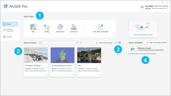
ArcGIS Pro is part of the ESRI suite and an extension to the ArcGIS desktop version. It provides advanced GIS tracking, geocoding, and mapping services to analyze various topographies and plan new initiatives.
I have been using ArcGIS products for a while now, and it has been quite a journey. One of the best things about this GIS tool is its geoprocessing power. When I am handling large datasets, running spatial analysis, or performing complex GIS operations, it provides data-driven functionalities to make everything run smoothly. For instance, according to G2 Data, 90% users praise its data visualization capabilities.
It also allows me to visualize data with pinpoint accuracy and build maps, whether I am working with raster files or vector data. Another huge win is the ability to integrate and collaborate. I was able to connect my workflows to ArcGIS Online or enterprise databases, allowing me to collaborate more effectively with my team.
However, although ArcGIS Pro offers end-to-end geographical tracking, it can be resource-intensive. If I’m not running it on a high-end machine, it may lag, though on capable hardware, the platform performs smoothly and efficiently.
Geoprocessing, one of my favorite features, can sometimes take longer than expected and occasionally cause the app to crash. Some G2 users have noted that certain workflows feel less intuitive compared to the older ArcMap interface; however, once familiar with the tools, the workflow becomes much easier to manage.
Pricing depends on the plan I choose, and some premium features are available only through paid subscriptions. While cloud integration is a significant advantage, working with large datasets over a slower network may require extra patience; however, it still enables powerful remote collaboration and data management.
That said, ArcGIS Pro offers a comprehensive suite of GIS tools that integrate seamlessly with real estate, construction, and urban planning projects, enabling effective optimization of facility operations and supporting advanced spatial analysis.
"ArcPro is an improvement from ArcGIS Desktop and an excellent all-around GIS software. Plenty of ready-to-use tools for geospatial analysis. It has a perfect modern look and feel, and is just as powerful, if not more, than the desktop. Its cartographic abilities are lovely for creating good visual representations of data. Its integration with ArcGIS online is very well done and critical for our workflow. We use it for georeferencing historical maps, managing project databases, and creating figures for reports."
- ArcGIS Pro Review, Manuel L.
"Large bandwidth is necessary; some features may only be available with an upgrade and a home server."
- ArcGIS Pro Review, Ryan D
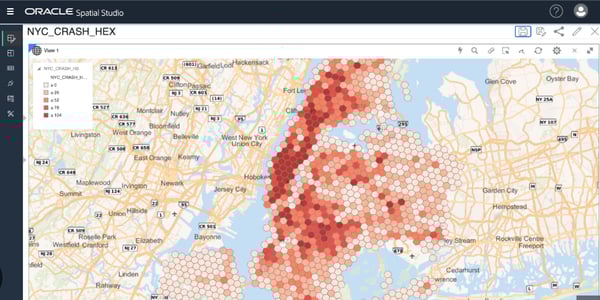
Oracle Spatial is a self-service application that manages your land-centric operations, providing features such as cartography, digital data processing, and photographic image processing to analyze various geographical locations.
Oracle Spatial isn't just another GIS tool; it is a powerhouse that provides a comprehensive set of spatial features designed for high-performance geospatial analytics.
One of this tool's greatest strengths is its ability to manage large-scale spatial data with remarkable speed and precision. Whether dealing with location-based services, geofencing, or network data modeling, Oracle Spatial provides a suite of features to streamline spatial analysis.
I was able to explore flagship features, such as R-tree and Quadtree indexing, which ensured that queries execute efficiently even on massive datasets. Additionally, it offered advanced geoprocessing functions, such as buffering, spatial joins, and coordinate transformations, and supported a variety of data formats.
With support for industry standards like OGC (Open Geospatial Consortium) and interoperability with tools like ArcGIS and QGIS, it offered flexibility for a variety of business use cases.
As prominent as Oracle is, I noticed that getting it up and running took some time. The setup and configuration process can be complex and requires a solid understanding of Oracle Database. Without that expertise, performance tuning may require extra effort; however, once configured, the system runs reliably.
While the array of features is impressive, they come at a cost. After analyzing licensing fees and conditions, I found that they could be a consideration for teams with tighter budgets. For those seeking an open-source alternative, the pricing may feel a little steep, but the robust capabilities often justify the investment.
That said, Oracle provides agile and unified geoprocessing and geospatial analysis services, which can be highly valuable for informing your next construction project planning and enhancing project efficiency.
"The best part about Oracle is the fact that the user interface is very simple to learn and use. I have used several different software programs, and nothing comes close to being able to do what Oracle can do in the same amount of time. The best part is I can teach all my new employees how to use this in about an hour instead of taking all day."
- Oracle Spatial Review, Austin P.
"A little bit cumbersome, but it is understandable due to the complexities involved in piecing together everything. For beginners, learning can be a bit challenging, but it's always there when you have such an innovative solution."
- Oracle Spatial Review, Verified User in Education Management.

The best open-source GIS software is QGIS, as it provides real-time GPS tracking, geoprocessing, and extensive plugin support for collaborating with stakeholders, sharing findings with the general public, and building empathetic policies and laws.
For beginners, QGIS is the best GIS software due to its free access, user-friendly interface, strong community support, and plenty of tutorials. ArcGIS Online is another great option for those who prefer a cloud-based, intuitive experience with simplified GIS tools.
Global Mapper Pro excels in handling large datasets, LiDAR processing, and terrain analysis, thanks to its intuitive interface, making it an ideal choice for industries such as forestry and surveying. However, QGIS offers more extensive plugin support, better cartographic tools, and a strong open-source community.
QGIS is a cost-effective, open-source GIS software with strong community support, making it ideal for customization and flexibility. While expensive, ArcGIS offers advanced features, enterprise-level support, and seamless integration with proprietary datasets, making it better suited for large organizations and high-end analysis.
Most leading GIS software support API and webhook automation services, as well as database connectors (including REST, SOAP, and SQL), for seamless integration. Ensure your GIS system is compatible with your network infrastructure and supports cloud operations to simplify the integration process and transfer data in a more compatible and efficient capacity.
MGIS software offers real-time location tracking and GPS tracking, enabling you to optimize logistics and utility operations while receiving up-to-the-minute updates on factory assets. It also helps businesses predict risks, optimize resource allocation, and improve response and evacuation strategies.
Yes, GIS software enhances geospatial risk management to protect facilities, infrastructure, and people from climatic or seasonal alterations. It analyzes historical data, seismic information, and other tectonic data to provide a comprehensive risk management plan.
Given that the environmental conditions are shaky and finicky, your team has to factor in business goals, budget, resources, and AI/ML network bandwidth to see how a GIS tool is compatible with your current network infrastructure.
With my analysis, I perceived simpler and agile ways in which teams can analyze geographical conditions, design zones, and properties, and remotely administer their projects in a way that would benefit both the company and mankind. Before you set up your next land project, evaluate your picks and give this piece a minute to read to see which tool aligns better with your expectations.
If you are starting your first construction project, refer to this list of the best construction accounting software in 2025 to manage your accounting ledgers and optimize contractor operations.
.png)

How do companies tackle challenges that span across various regions and countries?
.png) by Devyani Mehta
by Devyani Mehta

There have been times when I’ve spotted a halfway-through construction project that gets...
by Shreya Mattoo

Whether you’re a hobbyist sketching out ideas, a student learning design, or a professional...
 by Samudyata Bhat